Monday, July 28, 2008

News on the oil spill in New Orleans


The story line, “Things are almost back to normal on the Mississippi River” isn't so. That is what I’m hearing from the national media and the local media too. Their information source is the Coast Guard, who are carefully controlling access both to the scene of the spill and the information the public is allowed to hear. They mention that the clean up is ongoing, but the illusion that things are greatly improving along the river bank isn’t what I am finding when I explore with my camera in hand. Starting from the shores in the French Quarter going down almost as far as Venice, where the river meets the coast, I have documented a different story.

Interest in the story is limited – The clean up is under control and the river is open. The story is over. Over? Only 77,000 gallons of oil mixed with water have been cleaned up out of the over 400,000 spilled, the barge is still wedged up against the Crescent City Connection. According to the briefing I attended today, the oil still in the tanker will be sucked out by divers, and it will still be days before the remaining vessels are removed. Is it leaking or not?

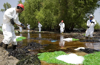
Each morning the workers find a fresh coat of oil where they left the day before in a much cleaner state.The massive clean up effort underway, described in the media as starting day two after the spill, was an exaggeration. The media were escorted to one spot where workers were cleaning – a couple of hundred workers, a photo op that made it into the newspaper and TV news. Monday the number of clean up crews is 1200; Tuesday it will be up to 2000. 2000 workers to cover 100 miles of coast that each day gets new deposits of oil, some of which is being spread by the boats that are once again moving on the river- some from the tanker which may or may not still be leaking, that can be described as massive. Yet from day two of the spill the media was describing a massive clean up when a couple hundred workers were on the scene A clear exaggeration. The amount of money changing hands post oil spill? Now that is massive. Deciding who gets the contracts and then the clean up companies getting set up, that has in fact taken a week.

On Saturday the coast guard showed the media the boat cleaning process. I saw first hand how boats that were contaminated near the site of the spill, were being cleaned off before being allowed to move upriver. At the briefing this morning it was reported that the first boat let through the oil filled waters wasn’t bad at all. By tomorrow afternoon all of the priority vessels that have been held up will have been sent on their way, and the river traffic will get back to normal by Wednesday. Questions remain- what is a clean vessel? - How much oil is it permissible to track into the Gulf of Mexico or up River? Who decides these amounts? Is the Government making it up as they go along or is there a way to regulate such things? I think a lot of the weights and measures are biased on how long the economy can afford the port being closed.

I photographed clean up crews on Sunday after being told not to-"for my own safety," I wasn't allowed anywhere down the levees. That didn't stop me. A basic rule in photography is to get a close as possible.

The workers told me though they cleaned the site the day before, today they were finding new oil on the surface: just as big a mess as when they first started. The clean up will go on for months. The process is in steps – first remove the oil on the surface (mopping with pompoms and using a boom to collect and stop the flow of the oil) then on the rocks (steam cleaning); then in the soil (dig it up and sift it). . The riverbank will need to be cleaned and re- cleaned until the EPA decides the workers are more disruptive to the eco-system than letting nature finish the job.

Though a small spill in comparison to the Exon Valdez (this spill is one-26th the size), it has other implications on the political landscape. On the 23rd, the day of the spill, McCain was meant to come to town and speak about how great off shore drilling will be for Louisiana and the country. His advisors had the good sense to cancel his visit. How would it look to have McCain taking a first hand look at what an oil spill looks like?

Oil fuels all the main stories of the day- The War, inflation due to the high cost of gas, the destruction of our eco-system: especially in Louisiana where the results of oil companies' works have wreaked havoc on the wetlands: the wet land being the first defense against storm surges such as the one caused by Katrina. Just before the spill congress decided protecting the wetlands wasn’t a local issue but a national one. This spill illustrates the fact that if the port of New Orleans is closed the whole country stands to be affected by the economic impact in the disruption of cargo.


Ironically, the area right at Tulane’s Natural History Museum is one of the most oil covered. This is a museum that Hank Bart (the director) and I have been working to open to the public. Our shared goal has been to educate people about their connection to the natural environment. Though a small spill compared to others in recent times, this one is a reminder that our dependency on oil is something we will have to reckon with, be it in the form of wars for control of resources, or the environmental impact from spills and usage.

Note on images- Images of workers and oil by the river bank are in Belle Chase near Tulane's Natural History Museum. I  took them on July 28th. The other images were shot  between July 25- 27 in the same area.


here is a link to a related article "EPA urges workers not to talk to media"

Thursday, July 24, 2008

Oil Spill in New Orleans: approximately 400,000 gallons of it


Yesterday when I learned of the spill I went over to the banks of the Mississippi in the French Quarter and took some pictures. The smell of the fuel oil polluting the air: it's noxious qualities enough  to give me a headache. Not a good day to sit at Café du Monde to sip café au lait and eat beignets .

Close to 1/2-million gallons of  crude oil spilled into the Mississippi River when a 600-foot Liberian flagged tanker called the Tintomara ran into a barge being pulled by a tugboat at 1:30 am.The clean up began yesterday, though it is still not operating on a massive scale as yet. The Mississippi is closed from New Orleans to the Gulf of Mexico (over 100 miles). There are disruptions in the ferry service in the area (for the most part it is completely closed down) and in the water service. Water will have to be trucked in to many of the municipalities. A major traffic pile up has begun on the river.
It was first reported that much of the oil would evaporate, but that isn’t the case. The oil is too thick and if not skimmed off the top of the river, it will sink. A handful of clean up crews were working all through the day yesterday and this morning. They are using a couple different techniques to remove the oil. One is laying out pom-pom like devices tied together along the coast to absorb the oil; another uses a boat that has a belt like apparatus that laps up the oils.

The investigation into the crash has revealed the tugboat operator had only an apprentice mate’s license and wasn’t qualified to be at the wheel. There are also rumors on NOLA’s website, in the comment section, after today’s article on the spill, claiming the operator had been fired for a failed drug test but then allowed back at a lower status. Whatever the case, this is the kind of crime that leaves us all victims. The ecosystem of Louisiana, the wetlands in particular, are fragile and already stressed by industry. New Orleans' first defense against hurricanes has taken another blow. The negative impact this spill will have on the environment is a story in the making.
“Is it a big spill?”, someone at the agency I gave my images to try to syndicate, asked?

“What is considered a big spill these days?” I wonder. It's big.

Tuesday, July 22, 2008

Flood Street-Still in Ruins From End to End


This morning I rode my bike the length of Flood St. in the Lower 9th Ward, from the wharf on the riverside to the levy. Flood Street is in very bad shape. Little has been rebuilt. I passed only a couple of construction crews and a handful of volunteers who were doing some landscape- 
work. I called a friend to get a reminder of what the codes painted on the homes by rescue crews stand for. 
The number at the 6 o’clock part of the X, is where the number of dead is recorded. Zero, in the case of the turquoise home I photographed. My friend looked up my coordinates on google maps and told me it looks like a sea of blue tarps from above. The scarred landscape and homes with boarded up entry points, illustrates Katrina’s story. A telling hole in a roof of one building looks too deliberate to be wind damage. Someone must have hacked the roof open while escaping the rising water.
 I first visited Flood Street in November 2006. The irony of a street called Flood Street, was one too rich to pass by. 


The Battle Ground Baptist Church, closer to the levee where the water went over the roofs of most of the buildings, is still standing. Benches remain inside, but the mud and other rubbish has been cleaned off.


At 1806, I went in to reshoot a home I shot in April 2007. More of the contents have been removed and the lawn was now landscaped, but there are no signs any re-building. In the middle of the house was a picture of Jesus, that is no longer behind glass, as I found it in April, looking back at anyone who enters the empty room looking up at them. The most noticeable change since my last visit in February 2008, are the street signs. At that time most were still hand painted on posts. Now the street intersections sport new shinny signs marking Flood Street and its’ recovery.

Sunday, July 20, 2008

Bike ride down Desire St.


On Wednesday I rode my bike the length of Desire Street stopping to take pictures along the way. Club Desire, at the corner of Law Street, is in a state of ruin, just as I found it in November 2006. 

There are new signs of life across the street from the club; a crew of volunteers is rebuilding a row of homes. Also new, is a housing development at the end of Desire St, a fenced in community of new homes with fresh perfect lawns, lacking any of New Orleans’ authentic style. The generic bland homes making up the complex could be found in any suburban community elsewhere in America; a bittersweet sign of progress in the Post Katrina rebuilding process.

I got off my bike and chatted with a resident who is happy with the housing development.
Desire Street tells the story of a city on the mend. However, block-by-block one could come up with different interpretations of the same story.
No faded Mardi Gras beads decorating the new housing complex yet, but in a few years I suspect one will find them there as well.
The first picture I shot that day, where Desire Street begins, is of a swan sculpture with a cracked neck adorned with faded Mardi Gras beads. 

Next a graveyard, where when I accompanied the National Guard on their patrols witnessed many drug dealer being picked up. 
Posted here is an image of one of the many ruined houses still standing and a couple of  the destroyed markets with hand-painted sings.

Tuesday, July 15, 2008

Elysian Fields : New Orleans

At the end of the day I rode my bike the length of Elysian Fields. From the river to the lake. Blanche DuBois moved into her sister's place on Elysian Field only to be taken off to a mental institution by the end of Tennessee William’s a Street Car Named Desire, “I have always depended on the kindness of strangers", she said to the man who let her leave the premises without having to be put in a straight jacket. Much of Elysian Fields was flooded badly. Signs of Katrina’s wrath start as early as North Rampart and get progressively more intense as you approach the lake.On the ride back, I stopped at a red light where Elysian Fields intersects Humanity Street, took a picture and rode on.


Tuesday, July 08, 2008

Images shot July 6th and 7th almost 3 years after Katrina


Yesterday I rode my bike to the Lower 9th Ward to check out the progress since I left late February. More buildings have been torn down but I didn't notice too much in the way of rebuilding. 

I returned to the site of a school I shot last May at St. Maurice and N. Rocheblave.
The school has been torn down the the library remains intact and the rubble that was once the school is strewn about.  
I will head out that way again today in the afternoon's high sun after a day spent working behind my computer.  
To see more of my post Katrina images from a series I started in Nov. 06, click here - Post Katrina Set on Flickr

Sunday, July 06, 2008

Based in New Orleans for the summer of 2008

I have returned to New Orleans to spend the summer, arriving on the 4th of July in time to catch the fireworks over the Mississippi River. I’m staying in an apartment over a bakery in the Faubourg Treme. An area that wasn’t hit too badly by the storm. I will photograph how things have changed since Katrina, and document the 3rd anniversary of the storm on Aug 29th at the end of the summer, while carrying on with my project at Tulane’s Natural History Museum.
On my way here I stopped in Washington DC and was able to go behind the scenes in the Smithsonian.
 

Ann Juneau, a librarian at the Natural History Museum escorted me through the back rooms and introduced me to some of the staff. That museum has the biggest collection in the world. There are row after row of storage cases; it is mind-boggling. James Dean, in the bird department pulled out a couple of Auks forme to shoot.  The bird hall in the public museum area is in the process of being replaced by an ocean hall, so not many birds are left on display. I will return in September on my way back to NYC, and start a series on deep-sea coral specimens.
I also went to the Vietnam memorial to shoot, adding that site to my project on Dark Tourism. It is very moving to watch people who locate the names of those they lost on the wall. People do rubbings of the names of the deceased to take away as mementoes. 

It is one of the most successful memorials I have visited. Nothing kitsch or over sentimental about it. The memorial has a great sense of dignity and evokes a tragic sense of loss through its’ endless sea of names.
David Borden met me there and modeled for me despite the sun shining in his eyes. He runs an advocacy group fighting for social justice by way of trying to change the drug laws – called, Stop the Drug Wars Now.

My next stop was Montgomery, Alabama (driving a long stretch of road to get there– a good 13.5 hour drive from DC) to visit my friend Sue Jensen, who is a superb ceramic artist as well as a professor.


Before I headed out of town, we went to the Civil Rights Memorial so I could shoot another one of Maya Lin’s works.
 Unfortunately the fountain 
(an integral part of the memorial) wasn’t on. The guard told us people keep throwing coins in the fountain that lead to it breaking down. Even without the fountain running, the memorial had
 great resonance. 
It is located in Montgomery’s historic downtown, where a lot of old buildings are still standing; the place hasn’t been turned into a generic shopping 
mall quite yet.
The quote used in the memorial is one of the most poetic of Martin Luther King Jr's:. “….. Until justice rolls down like waters and the righteousness like a mighty stream”.
 The absence of the sound of running water served as an ironic reminder that justice is something that sometimes needs maintenance too.

My first full day in New Orleans, I wasn’t too ambitious, but I did stop my car to shoot a spot I shot over a year ago since the light fell on the sign much nicer this time around. The same couch, the same open door- the same closed car wash remain on the corner of Freret and Soniat Street.